
Site Location: Lat.: 47° – 33’ – 18”N.; Long.: 52° – 42’ – 49” W. (GPS: 47.5550624, -52.7136681). Railway Coastal Museum, 495 Water Street, St. John’s. Eastbound on the Trans-Canada Highway 1, take Pitts Memorial Drive/NL-2 E at Exit 41A toward St. John’s Downtown/Mount Pearl. Proceed for 14.9 km and take ramp to the right at the traffic light, immediately after the “Water St East/ Harbour Drive” exit onto Hamilton Ave. Take the ramp to the right at the next traffic light to be travelling westbound on Water Street. After you pass under Pitts Memorial Drive, the museum is the first building on the left.
Plaque Location: The plaque is located on a pilaster to the left of the entrance of the Railway Coastal Museum, 495 Water Street, St. John’s.

Plaque mounted on pilaster to left of Railway Coastal Museum Entrance. (Source: Google Street View)
Description: The Newfoundland Railway, with a narrow gauge of 1067 mm (3 ft. – 6 in.) and a total track length of 1458 km (906 mi.), operated from 1898 to 1988. Construction commenced in 1881 on the Avalon Peninsula but the Newfoundland Railway Company went into receivership in 1884. Branch lines to Harbour Grace and Placentia were completed in 1884 and 1888, respectively. In 1890, Montreal-based railway engineer/contractor Robert G. Reid (1842-1908) agreed to build and operate the line. The construction reached Port aux Basques in 1898, connecting there with a new ferry service to North Sydney, NS. In 1901, the Reid Newfoundland Co. was formed to operate the railway and related assets. In 1923, the colonial government nationalized the system as the Newfoundland Government Railway, which became the Newfoundland Railway in 1926. Upon Confederation, in 1949, the railway became part of the Canadian National Railway system. The railway was abandoned on October 1, 1988, after a significant federal-provincial agreement for highway improvements was reached.


Historic Significance: The railway was the longest narrow-gauge system in North America.
Its completion led to the development of natural resources in Newfoundland’s interior. In 1905, Reid, British investors named Harmsworth, and the colonial government partnered to form the Anglo Newfoundland Development Company to develop timber resources, including construction of a pulp and paper mill in Grand Falls.
Extensive military-related construction in the late ‘30s and early ‘40s demonstrated the value of the railway as a strategic asset. It was used to supply a new air force base at Gander and American military bases at Stephenville, Argentia and St. John’s. Given the lack of all weather roads and the threat of German U-boats, the railway provided a secure and reliable supply link to support the defense of North America and the Battle of the Atlantic.
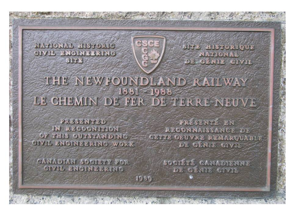
Plaque Wording: National Historic Civil Engineering Site. CSCE. THE NEWFOUNDLAND RAILWAY 1881-1988. Presented in recognition of this outstanding civil engineering work. Canadian Society for Civil Engineering, 1989.
SCGC. Site Historique National de Génie Civil. 1881-1988 LE CHEMIN DE FER DE TERRE-NEUVE. Présenté en reconnaissance de cette oeuvre remarquable de genie civil. Société canadienne de genie civil. 1989.
Links to Online Documentation:
Heritage Newfoundland and Labrador, “Railway”.
Heritage Newfoundland and Labrador, “Roads for Rails: The Closure of the Newfoundland Railway”.
“All Aboard! Exploring the Newfoundland Railway”, The Railway Coastal Museum.