Site Location: Lat.: 48° – 38’ – 53” N; Long.: 123° – 25’ – 43” W. (GPS: 48.6481032, -123.4286602) 1640 Electra Blvd, Sidney, BC. From the British Columbia Provincial Legislature, proceed 0.4 km east on Belleville Street towards Douglas Street and bear left (north) on Blanshard St/BC-17N. Proceed 24 km and bear right onto a ramp and, after 0.3 km, take the 3rd exit from the roundabout onto McTavish Rd. After 0.2 km, take the first exit from the roundabout onto Canora Road. Proceed 1.5 km, staying straight through the roundabout to go onto Willingdon Road and bear right (north) onto Electra Blvd. Proceed on Electra Blvd for 0.5 km: just after it turns hard left (west), the airport is on the right (north).
Plaque Location: The plaque is located within the BC Aviation Museum at 1910 Norseman Road, Sidney, British Columbia near the Victoria International Airport.
Description: In December 1939, Great Britain, Canada, Australia and New Zealand reached an agreement to train 1500 aircrew per month, starting in April 1940. The total estimated cost was $600 M and the estimated Canadian contribution, $350 M, was considerable given the total federal budget for 1939 was $500 M. The training rate peaked at over 3000 graduates per month. The total cost of $1.76 billion included a Canadian contribution of $1.59 billon.

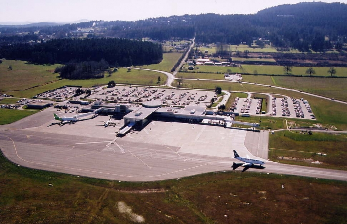
Patricia Bay Airfield was the home of No. 3 Operational Training Unit (November 1942 to August 1945), No. 32 Operational Training Unit (October 1941 to June 1944), and No. 13 Operational Training Squadron (October 1940 to October 1942. The field featured three 1520 m. (5000 ft.) long, 61 m. (200 ft.) wide, hard-surfaced runways and also accommodated flying boats. The Pat Bay Airport was the third largest station in Canada at the time and approximately 10,000 military personnel passed through this station. It remains in use today as the Victoria International Airport.
Historic Significance: The challenges for Canadian civil engineers working on the project included site selection and then the design and construction of runways, taxiways, roads, services, hangers, barracks and many other buildings to a very demanding schedule. The key to success was the development of standard airfield layouts and standard building designs using prefabricated wood components. In 1945, Winston Churchill described the BCAPT as “a spacious task imaginatively conceived and most faithfully carried out.” The initiative provided the foundation of Canada’s post-war air transportation network: of the 176 airfields constructed, 62 remain in service today including the Toronto and Vancouver International Airports.
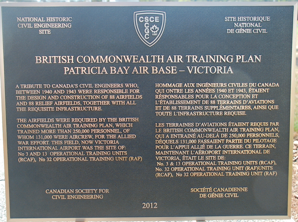
Plaque Wording: National Historic Civil Engineering. CSCE. BRITISH COMMONWEALTH AIR TRAINING PLAN PATRICIA BAY AIR BASE - VICTORIA. A tribute to Canada’s civil engineers who, between 1940 and 1943, were responsible for the design and construction of 88 airfields and 88 relief airfields, together with all the requisite infrastructure. The airfields were required by the British Commonwealth Air Training Plan, which trained more than 250,000 personnel, of whom 131,000 were aircrew, for the Allied war effort. This field, now Victoria International Airport was the site of: No. 3 and 13 Operational Training Units (RCAF), No. 32 Operational Training Unit (RAF). Canadian Society for Civil Engineering. 2012.
SCGC. Site Historique National de Génie Civil. CSCE. BRITISH COMMONWEALTH AIR TRAINING PLAN PATRICIA BAY AIR BASE - VICTORIA. Hommage aux ingénieurs civiles du Canada, qui ontre les années 1940 et 1943, étaient résponsables pour la conception et l’étabilssement de 88 terrains d’aviations et de 88 terrains supplémentaires, ainsi que toute l’infrastructure requise. Les terraines d’aviations étaient requis par le British Commonwealth Air Training Plan, qui a entrainé au-delà de 250,000 personnels, désquels 131,000 fassaient partie du pilotage pour l’appui allié de la guerre. Ce terrain maintenant l’aéroport Internationale de Victoria, était le site de: No. 3 & No. 13 Operational Training Units (RCAF), No. 32 Operational Training Unit (RAF). Société canadienne de génie civil. 2012
Plaque Unveiling Ceremony:
The plaque was unveiled on Friday, September 7, 2012. The event was organized by: Ramsay Murray, FCSCE, Member of the CSCE National History Committee; Kevin Baskin, FCSCE, Chair of CSCE Vancouver Island Section; Gerry Buydens, FCSCE Past Chair CSCE Vancouver Island Section; and Colin Smith, Chair of the CSSE Vancouver Island Section. CSCE Past-President Vic Perry attended the plaque unveiling on-behalf of the CSCE President and National Office. Approximately 60 people attended the unveiling, including local politicians, representatives from the Victoria Airport Authority, aviation industry, air force, historians, CSCE and CSSE Section members and the press.
Plaque unveiling. From left: Kevin Baskin, Vic Perry, Ramsay Murray. (Source: R. Black)
Links to Online Documentation:
https://www.canadianconsultingengineer.com/features/history-a-herculean-task/
https://www.veterans.gc.ca/eng/remembrance/history/second-world-war/british-commonwealth-air-training-plan
British Columbia Aviation Museum homepage