Site Location: Lat.: 53° – 33’ – 52” N.; Long.: 113° – 30’ – 59” W. (GPS: 53.5645668, -113.516379). Alberta Aviation Museum, 11410 Kingsway NW, Edmonton. From Trans-Canada Highway 16 – the Yellowhead Highway – take 121 Street NW south. Proceed 1.4 km and turn left (south east) at the T-junction onto Kingsway NW. Proceed 0.85 km and turn left on Airport Road NW and then immediately right on the first cross street. Proceed 0.1 km to the museum, on the left (north) side.
Plaque Location: The plaque is believed to be in storage at the Alberta Aviation Museum.
Description: In December 1939, Great Britain, Canada, Australia and New Zealand reached an agreement to train 1500 aircrew per month, starting in April 1940. The total estimated cost was $600 M and the estimated Canadian contribution, $350 M, was considerable given the total federal budget for 1939 was $500 M. The training rate peaked at over 3000 graduates per month. The total cost of $ 1.76 billion included a Canadian contribution of $1.59 billon.
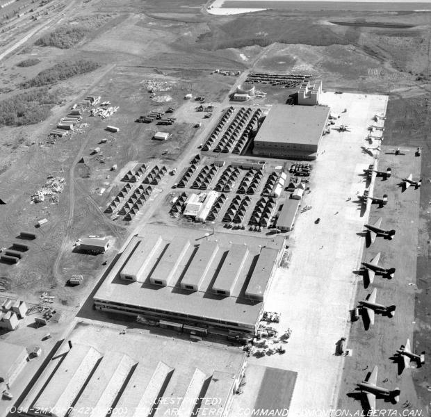
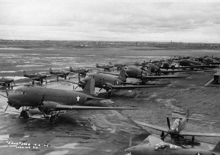
During World War 2 Blatchford Field was home to: No. 4 Initial Training School from June 8, 1941 to November 30, 1944; No. 16 Elementary Flying Training School from December 1, 1940 to July 17,1942; and, to No. 2 Air Observer School from July 1 1940 to July 26,1944. The field then had three 61 m (200 ft.) wide hard-surfaced runways, two 1740 m (5700 ft.) long and one 1370 m (4500 ft.) long.
Hangar 14, which now houses the Edmonton Aviation Heritage Centre, is an excellent example of the standard British Commonwealth Air Training Plan hangar design which could be doubled in length or width depending on the size or function of a school.
Historic Significance: The challenges for Canadian civil engineers working on the project included site selection and then the design and construction of runways, taxiways, roads, services, hangers, barracks and many other buildings to a very demanding schedule. The key to success was the development of standard airfield layouts and standard building designs using prefabricated wood components. In 1945, Winston Churchill described the BCAPT as “a spacious task imaginatively conceived and most faithfully carried out.” The initiative provided the foundation of Canada’s post-war air transportation network: of the 176 airfields constructed, 62 remain in service today including the Toronto and Vancouver International Airports.
Blatchford Field became the first licensed airfield in Canada in 1929 and was the hub of bush flying activities that made Edmonton ‘the Gateway to the North.’ During World War 2, it also served as the southern end of the Northwest Staging Route, a series of airfields between Edmonton, AB, and Fairbanks, AK, used to convey military supplies, including aircraft, to the Russian front. It became the Edmonton City Centre Airport and closed through a phased process between 2010 and 2013.

Hangar 14 is the only remaining double/double (double long, double wide) hangar in Canada. Its most notable structural feature is the roof, a modified Warren Truss System that spanning 34 m (112 ft.) without intermediate support.
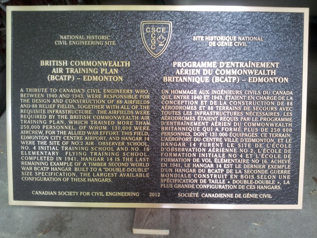
Plaque Wording: National Historic Civil Engineering. CSCE. BRITISH COMMONWEALTH AIR TRAINING PLAN – EDMONTON. A tribute to Canada’s civil engineers who, between 1940 and 1943, were responsible for the design and construction of 88 airfields and 88 relief fields, together with all the requisite infrastructure. The airfields were required by the British Commonwealth Air Training Plan which trained more than 250,000 personnel, of whom 131,000 were aircrew, for the Allied war effort. This field, Edmonton City Centre Airport, and Hanger 14 were the site of No. 2 Air Observer School, No. 4 Initial Training School and No.16 Elementary Flying Training School. Completed in 1941, Hanger 14 is the last remaining example of a timber Second World War BCATP hangar with a “Double-Double” size specification, the largest available configuration of these hangars. Canadian Society for Civil Engineering. 2012.
SCGC. Site Historique National de Génie Civil. PROGRAMME D’ENTRAÎNEMENT AÉRien DU COMMONWEATH BRITANNIQUE – EDMONTON. Un hommage aux ingénieures civils du Canada qui, entre 1940 et 1943, étaient en charge de la conception et de la construction de 88 aérodromes et 88 terrains de secours avec toutes les infrastructures nécessaires. Les aérodromes étaient requis par le programme d’entraînement aérien du Commonweath Britannique qui a formé plus de 250,000 personnes, dont 131,000 équipages. Ce terrain, l’Aéroport du Centre Ville d’Edmonton, et le Hangar 14 furent le site de l’école d’observation aérienne no. 2, l’école de formation initiale no. 4 et l’école de fformation de vol élémentaire no. 16. Achevé en 1941, Le Hanger 14 est le dernier exemple d’un hanger du PCATP de la seconde guerre mondiale construit en bois selon un specification de taille «double-double», la plus grande configuration de ces hangars. 2012. Société canadienne de genie civil.
Plaque Unveiling Ceremony: The plaque was unveiled at Hanger 14, the Alberta Aviation Museum, at the 2012 Annual Conference in Edmonton.
Links to Online Documentation:
Alistair MacKenzie, “HISTORY: A Herculean Task”, Canadian Consulting Engineer, 2001.
Veterans Affairs Canada, “The British Commonwealth Air Training Plan”.