Site Location: Lat.: 45° – 52’ – 19” N; Long. 64° – 18’ – 32” W. (GPS: 45.8719045, -64.3089243). Take the Highway 16 southwest from Trans Canada Highway 2 and, where it ends at a T-junction, turn right (north) on Aulac Road. After 0.7 km, keep left at a fork, and after 0.5 km, keep left at a second fork. Follow the road for another 1.1 km along the top of the dyke, including a sharp turn to the left, to the aboiteau. The aboiteau is marked with several interpretive signs, including the CSCE sign.
Plaque Location: Lat.: 46° – 6’ – 23” N; Long. 64° – 47’ – 20” W. (GPS: 46.1063416,-64.7888503). Départment de génie civil, université de Moncton, Faculté d’ingénierie, 57 Notre-Dame-du-Sacré-Coeur Street, Moncton.
Description: Acadians settling adjacent to the Baie Française (now Bay of Fundy) in the 17th Century faced low-lying saltwater marshes and heavily forested highlands. They had neither time nor resources to clear and grub the land for agriculture so used aboiteaux and diking techniques developed in Western France to turn the marshes into agricultural land. When the Acadians were deported in 1764, newly arrived Loyalists from New England took their farms but could not maintain the dykes and aboiteaux. To save the farmland and preserve the existence of the new settlers, the Colonial Government released imprisoned Acadians to serve the Loyalists by reconstructing and maintaining the aboiteaux.

Historic Significance: The key technology was the aboiteau, a covered channel through the dyke with an internal flap gate as shown schematically in the above figure. At high tide, the flap gate automatically closes, keeping the saltwater out. At low tide, it opens, releasing fresh rainwater to the sea. The time necessary to desalinate the marsh by leaching the salt with rainwater through the aboiteau could be as short as two years. By 1750, the Acadian colony had reclaimed 13000 acres (5300 hectares) of saltwater marsh.

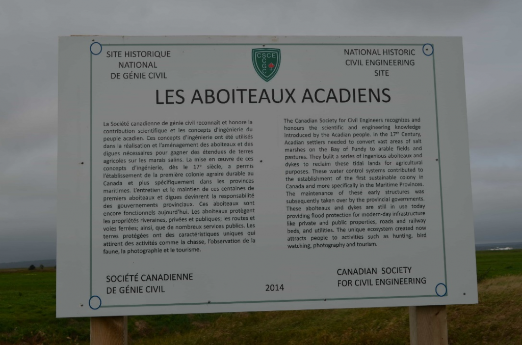
Plaque wording: Site Historique National de Génie Civil. SCGC. LES ABOITEAUX ACADIENS. La Société canadienne de genie civil reconnaît et honore la contribution scientifique et les concepts d’ingénierie du people acadien. Ces concepts d’ingénierie ont été utilizes dans la réalisation et l’aménagement des aboiteaux et des digues nécessaires pur gagner des étendues de terres agricoles sur les marais salins. La mise en oeuvre de ces concepts d’ingénierie, dès de le 17e siècle, a permis l’établissement de la première colonie agraire durable au Canada et plus spécifiquement dans les provinces maritimes. L’entretien et le maintien des ces centaines de premiers abouteaux et digues devinrent la responsabilité des gouvernments provinciaux. Ces aboiteux sont encore fonctionnels aujourd’hui. Les aboiteaux protègent les propriétés riveraines, privies et publiques; les routes et voies ferrées; ainsi, que de nombreux services publics. Les terres protégées on des caractéristiques uniques qui attirent des activités comme la chasse, l’observation de la faune, la photographie et le tourisme. Société canadienne de génie civil. 2014.
CSCE. National Historic Civil Engineering Site. LES ABOITEAUX ACADIENS. The Canadian Society for Civil Engineers recognizes and honours the scientific and engineering knowledge introduced by the Acadian people. In the 17th Century, Acadian settlers needed to convert vast areas of salt marshes on the Bay of Fundy to arable fields and pastures. They built a series of ingenious aboiteaux and dykes to reclaim these tidal lands for agricultural purposes. These water control systems contributed to the establishment of the first sustainable colony in Canada and more specifically in the Maritime Provinces. The maintenance of these early structures was subsequently taking over by the provincial governments. These aboiteaux and dykes are still in use today providing flood protection for modern-day infrastructure like private and public properties, roads, railway beds and utilities. The unique ecosystem created now attracts people to activities such as hunting, bird watching, photography and tourism. 2014. Canadian Society for Civil Engineering.
Plaque Unveiling Ceremony (October 18, 2017):

Plaque unveiling, at Université de Moncton. From left to right: Jérémie Aubé, P.Eng, Chair, East NB (Moncton) & PEI CSCE Section; Samuel Richard, P.Eng, Vice President, Atlantic Region, CSCE; Name unknown, President of the Student Union, UdeM; Name unknown, President of the UdeM Alumni; His Worship, Yvon Lapierre, Mayor, City of Dieppe; Bernard Lord, Co-President, Évolution, UdeM Funding Campaign; Bernard LeBlanc, Former Director, Musée Acadien, UdeM; Gilles Hébert, P.Eng, Secretary, East NB (Moncton) & PEI CSCE Section; Raymond Théberge, President and Vice Chancellor UdeM; The Honorable Jocelyne Roy-Vienneau, P.Eng. Lieutenant Governor NB; Ronald Vienneau, spouse to Lieutenant Governor; Gilles Roy, P.Eng, Dean, Faculty of Engineering, UdeM; Alistair MacKenzie, Chair, CSCE History Committee; and, Linda Schofield, UdeM Director of the Foundation Evolution. (Source: G. Hébert)